US 1937 Northwest Territory Sesquicentennial 3c. Scott. 795
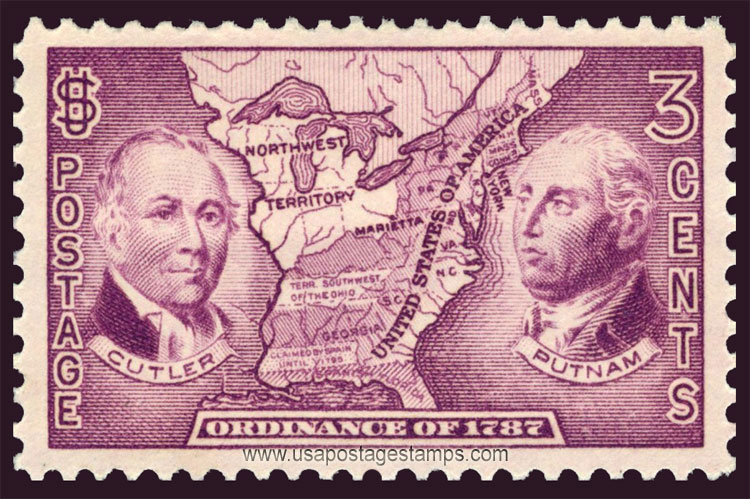
Series: Ordinance of 1787 Sesquicentennial Issue
Stamp details: Manasseh Cutler, Rufus Putnam and Map of Northwest Territory
Issued date: 13-07-1937 (dd/mm/yyyy)
Face value: 3c.
Emission: Commemorative
Watermark: No Watermark
Catalogue No:-
Scott (USA): 795
Stanley Gibbons (UK): 791
Michel (Germany): 402
Yvert et Tellier (France): 361
Dimensions (height x width):
25mm x 40mm
Printer: Bureau of Engraving and Printing
Print Method: Rotary Press
Stamp Colors: Red violet
Perforation: Perf 11 x 10½
Themes: Famous People, Map
Total print: 84,825,250 (estimate)
Description:- The Northwest Ordinance (formally An Ordinance for the Government of the Territory of the United States, North-West of the River Ohio and also known as the Ordinance of 1787), enacted July 13, 1787, was an organic act of the Congress of the Confederation of the United States. It created the Northwest Territory, the new nation's first organized incorporated territory, from lands beyond the Appalachian Mountains, between British North America and the Great Lakes to the north and the Ohio River to the south. The upper Mississippi River formed the territory's western boundary. Pennsylvania was the eastern boundary.
Source: en.wikipedia.org/wiki/Northwest_Ordinance
Source: en.wikipedia.org/wiki/Northwest_Ordinance
* Philatelic Auction Houses
* Philatelic Books
* Philatelic Federation
* Philatelic Libraries
* Philatelic Magazines
* Philatelic Society
* Stamp Dealers Association
* Stamps Exhibitions
* US Post Offices
* Worldwide Philatelic Bureau